Categories
Geography Science & Tech

The Indian Ocean’s Gravity Hole

  • The discovery of a substantial “gravity hole” in the Indian Ocean, where the gravitational attraction is noticeably reduced, is one curious phenomenon recently observed.
  • Recent study has given light on the potential causes of this phenomenon.

What is a Gravity Hole?

  • A “gravity hole” is a location on Earth where the gravitational attraction is much weaker than in surrounding areas or the global average.
  • It is distinguished by a dip or low gravity anomaly.
  • Because of the decreased gravitational force acting on the water in such places, the sea level may be lower than average.
  • This word is frequently used to characterise specific locales, such as the Indian Ocean geoid low (IOGL), where the gravitational attraction is significantly reduced in comparison to surrounding regions.
  • Gravity holes can have a variety of reasons, including changes in the Earth’s mass distribution or underlying geological characteristics.

What exactly is the Indian Ocean Geoid Low (IOGL)?

  • It is around 1,200 km southwest of India’s southernmost tip.
  • IOGL refers to an area in the Indian Ocean where the sea level is approximately 106 metres lower than the worldwide average.
  • Investigating the Root Causes of IOGL

Finding the Anomaly:

  • During a survey in 1948, geophysicist Felix Andries Vening Meinesz discovered the IOGL. It has since been validated by ship-based investigations and satellite observations.
  • The Indian Institute of Science developed computer-simulated models spanning 140 million years to test the Ancient Ocean Hypothesis. They uncovered the remains of an ancient ocean 965 kilometres into the Earth’s crust, directly beneath Africa.
  • The models indicated molten rock jets beneath Africa, which could be triggered by tectonic plates subducting into the mantle. These plumes are thought to have contributed to the IOGL.
  • Possible origins: According to the researchers, the IOGL is made up of slabs from the Tethys Sea, a long-lost sea that sank to the planet’s depths millions of years ago. The African Large Low Shear Velocity Province is thought to have been disturbed by the Tethys Sea, which previously divided the supercontinents of Gondwana and Laurasia.
Source: https://m.timesofindia.com/etimes/trending/theres-a-giant-gravity-hole-in-indian-ocean-and-scientists-have-finally-figured-out-how-it-was-formed/articleshow/101515305.cms
Categories
Geography

What is the Indian Ocean Dipole and how may it help mitigate the effects of El Nino?

With the El Nino phenomenon expected to have an impact on the Indian monsoon this year, there is growing confidence about the emergence of a positive Indian Ocean Dipole (IOD) and its ability to counteract El Nino’s consequences. The Indian Ocean Dipole (IOD), a weaker ocean-atmosphere interaction in the Indian Ocean, has had minimal repercussions in the past but has the potential to mitigate the negative effects of El Nino, particularly in nearby regions.

The Indian Ocean Dipole (IOD) and El Nino are now inactive

IOD:

  • The IOD is now in a state of neutrality. This means that there is no considerable temperature difference around the equator between the western and eastern sides of the Indian Ocean.
  • However, international climate models indicate that a positive IOD event may occur in the next months.
  • According to the India Meteorological Department (IMD), there is an 80% possibility of a positive IOD during the June-August 2023 season. A positive IOD would have ramifications for weather patterns in the Indian Ocean region.

El Nino:

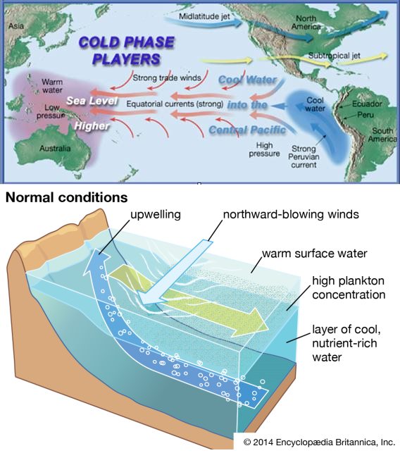
  • This year, El Nino has already established itself in the Pacific Ocean. El Nino occurs when the prevailing wind systems weaken, resulting in less warm water displacement in the eastern Pacific.
  • This unusual warming of the eastern Pacific has the potential to affect global weather patterns, especially the Indian monsoon. El Nino’s presence raises concerns about its potential impact on Indian monsoon rains.

The interaction between the El Nino Southern Oscillation (ENSO) and the IOD Triggering Mechanism:

  • ENSO occurrences, particularly El Nino, can cause a positive IOD to develop in the Indian Ocean.
  • External Drivers: While external influences like as ENSO can cause IOD events in some situations, there is evidence that IOD events can also occur as a result of local circulations or subsurface processes in the equatorial Indian Ocean.
  • Internal Dynamics: Even when sparked by external forces, IOD events evolve and mature predominantly through internal dynamics. They have the potential to live independently and influence weather patterns in the Indian Ocean region.
  • Influence on IOD: During El Nino, the Pacific side of Indonesia is cooler than usual, which influences the Indian Ocean side, resulting in the formation of a positive IOD.
  • Mutual Interaction: When both occurrences are strong, the circulation patterns of IOD and ENSO can have an impact on each other. The interaction of the two events can have an effect on the intensity and duration of each occurrence.
  • Positive IOD occurrences are frequently related with El Nino, whilst negative IOD events are sometimes associated with La Nina. This link, however, is not absolute, and IOD events can occur independently or with alternative associations depending on the circumstances.
  • Strong IOD and ENSO occurrences can have combined effects on weather patterns because their circulation patterns interact and influence one another.

The effects of the Indian Ocean Dipole Rainfall Distribution:

  • The IOD has a substantial impact on rainfall patterns in the Indian Ocean region. During a positive IOD, convection and rainfall rise along the African coastline and over the Indian subcontinent. A negative IOD, on the other hand, results in reduced rainfall in these areas.
  • Drought and Floods: Positive IOD events can provide above-average rainfall to impacted areas, alleviating drought and replenishing water resources. However, increasing rainfall can cause flooding and other water-related calamities in some locations.
  • Agricultural Productivity: IOD has ramifications for agriculture since it impacts rainfall availability and distribution. Positive IOD events can boost agricultural output in impacted areas, however negative IOD events can result in lower crop yields and agricultural issues.
  • Fisheries: IOD has an impact on marine ecosystem productivity. Increased upwelling of nutrient-rich waters occurs during positive IOD, which encourages higher fish stocks and improves fisheries. Negative IOD, on the other hand, can disrupt the marine food chain and have an influence on fish populations.
  • IOD influences sea surface temperatures, and sustained positive IOD events can contribute to higher sea surface temperatures in impacted areas. This can cause coral bleaching, which harms coral reefs and marine biodiversity.
  • Indian Monsoon: The intensity and spread of the Indian monsoon rainfall can be influenced by IOD. Positive IOD events are typically connected with increased monsoon rainfall over the Indian subcontinent, whereas negative IOD events might result in decreased monsoon rainfall.
  • Weather Extremes: IOD can contribute to the occurrence of extreme weather events in the Indian Ocean region, such as heatwaves, storms, and tropical cyclones.
  • Economic and social consequences: The effects of IOD on rainfall, agriculture, fisheries, and other industries have immediate economic and social consequences. These consequences can have an influence on livelihoods, water availability, food security, and overall economic development in the impacted areas.

El Nino’s Effects on the Indian Monsoon

  • Weakening Monsoon Winds: The trade winds that blow from the east across the Indian Ocean diminish during El Nino. These winds are in charge of transporting moisture-laden air to the Indian subcontinent, facilitating monsoon rainfall. Weakening winds restrict the supply of moisture, resulting in less rainfall.
  • Delayed Onset: El Nino might cause the Indian monsoon to arrive later than usual. The monsoon season typically begins in June in India, although during El Nino years, the arrival of the monsoon may be delayed, resulting in a late start to the rainy season.
  • El Nino events cause below-average rainfall in India due to reduced moisture transport and altered atmospheric circulation. Regional variations exist, with central and northern regions more susceptible to below-average rainfall, while southern areas may experience near-normal or above-normal rainfall.
  • El Nino-induced rainfall deficiency causes drought, affecting agriculture, water availability, and livelihoods. Increased temperatures during monsoon season in India cause heatwaves, health risks, and impacts human well-being.

Conclusion

The Indian Ocean Current (IOD) has limited ability to counter El Nino’s effects, but a positive IOD event could be expected in the coming months. Past strong IOD events have shown IOD’s potential in compensating for monsoon rainfall deficits.

Source: https://indianexpress.com/article/explained/explained-climate/indian-ocean-dipole-what-is-it-how-it-can-limit-el-nino-effects-8689360/
Categories
Geography

Understanding Summer Solstice: The Year’s Longest Day

  • For people living north of the Equator, the summer solstice, often known as the longest day of the year, comes on June 21st.
  • This article delves into the meaning of the summer solstice, the causes for its existence, and the affects it has on various parts of the world.

What exactly is the Summer Solstice?

  • The summer solstice occurs when the Earth’s axial tilt is greatest inclined towards the Sun.
  • It happens every year on or around June 21st in the Northern Hemisphere.
  • The Sun takes its highest and longest trip across the sky at the summer solstice.
  • As a result, the daytime hours are prolonged, making it the longest day of the year.

Summer Solstice Influencing Factors

  • The Axial Tilt of the Earth: The Earth’s axis is tilted at an angle of around 23.5 degrees relative to its orbit around the Sun.
  • The summer solstice occurs when the Sun is directly over the Tropic of Cancer, which is located at 23.5 degrees north latitude.
  • Seasonal Changes: Because of the tilt of the Earth’s axis, various latitudes receive varied quantities of sunlight throughout the year.

The Distribution of Sunlight in the Hemispheres

  • The Northern Hemisphere receives the most sunlight during the summer solstice, which occurs on June 20, 21, or 22.
  • The Southern Hemisphere, on the other hand, experiences its highest sunshine on the winter solstice, which falls on December 21, 22, or 23.

Celebrations and Cultural Importance

  • Throughout history, the summer solstice has had cultural and religious significance in numerous civilizations.
  • This celestial event is frequently commemorated through festivals and ceremonies, symbolising the triumph of light and fertility.
  • Festivals, bonfires, music, dancing, and outdoor activities are held all around the world to commemorate the summer solstice.
  • The Summer Solstice Stonehenge Festival in England and the Midnight Sun Festival in Norway are two notable festivities.
Source: https://economictimes.indiatimes.com/news/international/us/why-jun-21-is-years-longest-day-what-is-summer-solstice/articleshow/101166962.cms
Categories
Geography

What is El Nino, and how does it affect the Monsoon?

  • Monsoon Delay: Any discussion of the Indian monsoon delay these days must include mention of the El Nino phenomenon.
  • El Nino’s unexpected rise: This year’s monsoon is also moving under the shadow of an El Nino in the Pacific.

El Nino and La Nina: What You Need to Know

  • The El Nino and La Nina phases of the El Nino-Southern Oscillation (ENSO) cycle are diametrically opposed.
  • ENSO is a naturally occurring occurrence in the equatorial Pacific that involves the interplay of the ocean and atmosphere.

A full comparison between El Nino and La Nina is provided below:

El NinoLa Nina
DefinitionWarmer-than-normal sea surface temperaturesCooler-than-normal sea surface temperatures
FrequencyEvery two to seven yearsEvery two to seven years
DurationSeveral months to a year or moreSeveral months to a year or more
Impact on windsWeakens trade winds, leading to changes in patternsStrengthens trade winds, leading to changes in patterns
Impact on rainsReduces rainfall and can cause droughtsIncreases rainfall and can cause flooding
Impact on temp.Warmer-than-average temperaturesColder-than-average temperatures
Global effectsDroughts in Asia and Africa, floods in AmericasFloods in Asia and Africa, droughts in South America

Impact on India

El NinoLa Nina
Associated with weak monsoons and drought-like conditions in IndiaAssociated with above-normal rainfall and floods in India
Sea surface temperature in the equatorial Pacific Ocean rises above normal levelsSea surface temperature in the equatorial Pacific Ocean drops below normal levels
Changes in the atmospheric circulation patternsChanges in the atmospheric circulation patterns
Shift in the location of the jet stream, affecting the strength and direction of the monsoon windsIncrease in the strength of the monsoon winds, bringing more moisture and rainfall to India
Results in reduced rainfall, dry spells, and heatwaves, leading to crop failures and water scarcityExcessive rainfall can also lead to floods and landslides, causing damage to crops and infrastructure

El Nino and Indian Monsoon

  • El Nino and its impact on Indian monsoon: El Nino refers to abnormal warming of surface waters in the equatorial Pacific Ocean, which tends to suppress monsoon rainfall in India.
  • El Nino weather patterns Southern Oscillation (ENSO): In the Pacific Ocean, ENSO has three phases: El Nino, La Nina (excessive cooling), and a neutral phase with sea surface temperatures close to long-term averages.
  • ENSO includes not just temperature anomalies in sea surface waters, but also atmospheric factors such as changes in sea-level air pressure and wind strength and direction.
  • Southern oscillation and the effect of winds: The Southern Oscillation Index monitors the difference in sea-level air pressure between the western and eastern Pacific Oceans, whereas wind patterns play an important influence in ENSO.

El Nino precipitating factors

  • Weakening trade winds: When trade winds in the tropical Pacific weaken, it contributes to El Nino by slowing the migration of warm surface waters.
  • Changes in ocean current patterns: Changes in ocean current patterns can cause El Nino episodes because they impact the distribution and buildup of warm water in the central and eastern Pacific.
  • Changes in atmospheric pressure: Fluctuations in atmospheric pressure patterns disturb the regular circulation associated with trade winds, causing El Nino conditions to develop.
  • The presence and behaviour of oceanic Kelvin waves, large-scale waves that transfer warm water eastward, influence the genesis and intensification of El Nino occurrences.
  • Interactions with other climatic modes: El Nino can be influenced by interactions and connections with other climate phenomena such as the Indian Ocean Dipole and the Madden-Julian Oscillation, both of which can affect oceanic and atmospheric conditions in the Pacific region.

Measuring the Cycle

(1) Oceanic Nino Index (ONI)

  • The oceanic component of the El Nino Southern Oscillation (ENSO) is measured.
  • The deviation from average sea surface temperatures in the tropical Pacific Ocean is tracked.
  • It assists in quantifying the intensity and length of El Nino and La Nina occurrences.
  • A rolling three-month average of sea surface temperature anomalies in certain regions is typically used.

(2) Southern Oscillation Index (SOI)

  • ENSO’s atmospheric component is measured.
  • The difference in air pressure between Tahiti and Darwin is calculated.
  • Positive SOI levels imply that pressure is higher in the eastern Pacific and lower in the western Pacific.
  • Negative SOI levels imply that pressure is lower in the eastern Pacific and higher in the western Pacific.
  • Reflects the strength and changes in ENSO-related atmospheric circulation patterns.
  • The phase and strength of ENSO, as well as its impact on global weather and climate patterns, are assessed.

El Nino’s Economic Impact on Indian Agriculture

  • Drought and reduced rainfall: El Nino occurrences frequently result in below-average monsoon rainfall in India, causing drought conditions in various places.
  • Crop failure and lower yields: Crop failure or lower yields for major crops such as rice, wheat, pulses, and oilseeds can occur due to a lack of adequate water availability.
  • Increased input costs: During El Nino-induced droughts, farmers may need to spend in more irrigation, water management, and supplementary livestock feeding, resulting in higher input costs.
  • Price changes: Because of El Nino, crop production may be reduced, causing price swings and potential inflation in food costs.
  • Water scarcity and changes in marine habitats can have a severe impact on animal husbandry and fishing activities, hurting the lives of individuals who rely on these industries.
  • Rural livelihoods and migration: Economic hardship can have an impact on rural livelihoods, causing more people to migrate from rural to urban regions in pursuit of alternative employment options.

Source: https://indianexpress.com/article/explained/explained-climate/what-is-el-nino-and-how-it-impacts-the-monsoon-8661546/#:~:text=El%20Nino%2C%20as%20is%20commonly,to%20aid%20rainfall%20over%20India.
Categories
Environment & Biodiversity Geography

Cyclone Biparjoy and Its Naming In the Arabian Sea

  • A cyclonic storm known as Biparjoy has formed. It is a tropical cyclone.
  • It was based about 850 kilometres west of Goa and 900 kilometres southwest of Mumbai.
  • The cyclone is expected to strengthen over the next three days and become a severe cyclonic storm by June 13.
  • It would provide squally weather with wind gusts reaching 35-45 kmph in the Karnataka, Goa, and Maharashtra coastlines.
  • The IMD has not yet anticipated any significant influence on Arabian Sea countries such as India, Oman, Iran, and Pakistan.

How did it get its name?

  • The name ‘Biparjoy’ was suggested by Bangladesh, and the word means ‘disaster’ or ‘calamity’ in Bengali. Following Biparjoy, the following cyclone will be named ‘Tej’ at the request of India.
  • Rotating Basis for Naming: Countries name cyclones on a rotating basis, following certain existing standards.
  • RSMC and TCWC Responsibilities: There are six regional specialised meteorology centres (RSMCs) and five regional Tropical Cyclone Warning Centres (TCWCs) in charge of issuing advisories and identifying tropical storms around the world.
  • IMD’s Role: Under the WMO/Economic and Social Commission for Asia-Pacific (ESCAP) Panel, IMD is one of six RSMCs providing tropical cyclone and storm surge alerts to 13 member nations.
  • The IMD: RSMC, New Delhi, is also tasked with naming tropical cyclones that form over the north Indian Ocean, encompassing the Bay of Bengal and the Arabian Sea.
  • Naming Guidelines: When naming cyclones, some principles must be followed, such as remaining politically, religiously, culturally, and gender neutral, avoiding insulting or cruel names, and making the name brief and easy to say.
  • Following Bangladesh, the next cyclone will be called ‘Tej’ based on India’s recommendation.

A Quick Recap of the Arabian Sea Cyclones

  • Cyclone Frequency: It is not uncommon for cyclones to form in the Arabian Sea. There are fewer cyclones than in the Bay of Bengal, although they do occur.
  • Months that are favourable: June is one of the best months for cyclone formation in the Arabian Sea.
  • Cyclone Formation Factors: Cyclones form as a result of low-pressure systems over warm water. The Bay of Bengal is slightly warmer, but the Arabian Sea is also warming owing to climate change, which is increasing the number of cyclones.
  • Weather Systems and the Coriolis Effect: The Coriolis Effect causes air to blow in an anticlockwise direction in the northern hemisphere during a depression or low-pressure situation.

Climate Change’s Role

  • The frequency of extremely severe cyclonic storms has grown across the Arabian Sea since 1990, but it has remained constant over the Bay of Bengal.
  • A 2021 study found that the strength, frequency, and duration of cyclonic storms in the Arabian Sea were increasing.
  • The roughly quadrupled collected cyclone energy indicates warming, reflecting the amount of warming in recent years.
Source: https://www.business-standard.com/india-news/storm-chasing-here-s-how-cyclone-biparjoy-got-its-name-and-more-123060800789_1.html#:~:text=How%20did%20the%20cyclone%20get,(WMO)%20countries%20in%202020.
Categories
Geography

Location: Ukraine’s Kakhovka Dam

  • Dnipro River Dam Breach: A Soviet-era Kakhovka Dam on the Dnipro River in southern Ukraine was burst, causing flooding to spread over the battle zone.
  • Conflicting Accounts: Ukraine accused Russia of destroying the dam, but Russian officials offered conflicting explanations, pointing to Ukrainian bombardment or previous damage as possible causes.

The Kakhovka Dam

  • It was completed in 1956 as part of the Khakhovka hydroelectric power project, and has a height of 30 metres (98 feet) and a length of 3.2 kilometres (2 miles).
  • Water Supply: The dam’s reservoir provides water to the Crimean peninsula, which Russia has claimed since 2014, as well as the Zaporizhzhia nuclear power station, which is also under Russian control.
  • Reservoir Capacity: The reservoir holds approximately 18 cubic kilometres of water, which is comparable in capacity to Utah’s Great Salt Lake.

Reports on the Dam Breach

  • Ukrainian Accusations: Ukraine blamed Russia, claiming the dam was damaged by “Russian terrorists” and accused Russian occupation forces of the crime.
  • Russian Claims: Russian-installed officials provided contradictory stories, with some blaming Ukraine for shelling the dam and others claiming the dam broke owing to pre-existing damage and water pressure.

Evacuations and Human Impact

  • Potential Flooding: The rise in flood levels poses a considerable risk, with thousands of individuals in the impacted areas potentially affected.
  • Evacuations: Evacuation activities began on both sides of the front line to protect civilian safety.
  • At Risk Population: Russian-installed officials said 22,000 people in 14 settlements in Ukraine’s southern Kherson region were at risk of flooding, while the Ukrainian Prime Minister said up to 80 settlements were at risk.

Impact on Crimea

  • Concerns regarding water levels in the North Crimea Canal, which feeds fresh water to the Crimean peninsula from the Dnipro River, have been raised as a result of the dam break.
  • Dependence on the Canal: Crimea relies on the canal for fresh water, and its earlier closure by Ukraine following the 2014 takeover resulted in regional water shortages.
  • Potential Consequences: Reduced water levels in the canal could have serious consequences for Crimea’s water supply.

Other hotspots under concern include:

  • Zaporizhzhia Nuclear Power Plant Cooling Water Source: The reservoir serves as a source of cooling water for Europe’s largest nuclear power plant.
  • Russian Control: The factory is located on the conflict zone’s southern edge, which is currently under Russian control.
  • Assurance of Nuclear Safety: The International Atomic Energy Agency declared that there was no immediate threat to nuclear safety at the Zaporizhzhia Nuclear Power Plant, and Russia’s official nuclear energy organisation confirmed that the plant was safe.
Source: https://www.theguardian.com/world/2023/jun/06/visual-guide-collapse-ukraine-nova-kakhovka-dam
Categories
Geography

The Palghat Gap is a rift in the Western Ghats

The Palghat (Palakkad) Gap, a key corridor in India’s Western Ghats, is discussed in this article. It tells us about the geological genesis of the gap.

What exactly is the Palghat Gap?

  • The Palghat Gap is a 40-kilometer-long corridor in the Western Ghats famed for its steep hills that serves as a doorway to Kerala.
  • It is a vital link for roads and trains between Coimbatore and Palakkad.
  • The Palghat Gap is crossed by the Bharathappuzha River.
  • The vegetation in the gap is described as dry evergreen forest, as opposed to the Western Ghats’ tropical rainforests.
  • The Palghat Gap marks a unique split in the region’s flora and fauna.

Geological origin of the Palghat Gap

  • The Palghat Gap is a geological shear zone running from east to west.
  • Shear zones are weak areas in the Earth’s crust that cause tremors in the Coimbatore area on occasion.
  • The Palghat Gap formed when the continental shelf changed following the separation of Australia and Africa from the Gondwana landmass.
  • India and Madagascar were once connected until volcanic activity caused their separation, with a similar gap in Madagascar known as the Ranotsara Gap.

Ancient history and biogeographic differences

  • The biogeographic differences in species found north and south of the Palghat Gap could be linked to an old river or a sea intrusion in the distant past.
  • Elephant populations on the Nilgiris side of the gap have mitochondrial DNA that differs from elephant populations in the Anamalai and Periyar sanctuaries.
  • DNA research of the White-bellied Shortwing, an endemic bird species, reveals population divergence in the Nilgiris and Anamalai regions.

South of the Palghat Gap, biodiversity

  • The southern Western Ghats region, south of the Palghat Gap, has a high species richness and phylogenetic diversity.
  • A recent study found over 450 tree species, including 130 million-year-old species like Magnolia champaca.
  • The southern Western Ghats’ warm temperature and moist air support a varied spectrum of species, making it an island haven throughout ice ages and droughts.
  • In comparison to the northern part, the southern Western Ghats receive more equally distributed rainfall throughout the year.
Source: https://www.thehindu.com/sci-tech/science/a-break-in-the-western-ghats/article66845725.ece#:~:text=Often%20called%20as%20a%20significant,into%20the%20State%20of%20Kerala.
Categories
Economics Geography

Map of India’s Export Hubs

The article highlights India’s top exporting districts and their contribution to the country’s overall exports. It also includes data on the top export commodities in each district.

Top Exporting Districts in Each State

  • The diameter of the circle on the map represents the value of exports.
  • Most top exporting districts in the north-eastern states accounted for up to 90% of a state’s exports, while others accounted for only approximately 20% of a state’s exports.

Top Commodities Exported

  • Jamnagar’s domination can be linked to the fact that it accounted for the lion’s share of India’s growing petroleum exports, whilst smartphones were the most exported commodity from Kancheepuram.

Top Exporting Regions by Commodity

  • Petroleum items, precious stones and jewellery, rice, wheat, and other grains, smartphones and electronic parts, non-railway cars, and medicinal products are among them.

Top Exporting Commodity Share

  • Jamnagar’s exports of petroleum products accounted for 67% of India’s total exports of that commodity, while Surat’s exports of precious stones and jewellery accounted for 36% of India’s total exports of that commodity.
Source: https://exporthubs.gov.in/
Categories
Economics Geography

Project for the Eastern Rajasthan Canal (ERCP)

Rajasthan has raised the Eastern Rajasthan Canal Project (ERCP) with the Prime Minister.

Why is this in the news?

  • The Chief Minister has stated that the state government cannot bear the estimated project cost of around Rs 40,000 crore on its own.
  • The state wants the Centre to declare this a national project, resulting in a 90:10 cost-sharing ratio between the Centre and the state.

Eastern Rajasthan Canal Project (ERCP)

  • Project for the Eastern Rajasthan Canal (ERCP)
  • ERCP was established with the goal of providing water to the state’s drought-prone areas.
  • It aims to harvest excess water in rivers in southern Rajasthan, such as the Chambal and its tributaries Kunnu, Parvati, and Kalisindh, during the rainy season.
  • The project entails the construction of two canals: the Chambal Canal (which flows from the Chambal River) and the East Rajasthan Canal (which originates from the Mahi River)
  • The ERCP is expected to irrigate approximately 3.4 million hectares of agricultural land in the states of Rajasthan and Madhya Pradesh.
  • It is expected to cost around Rs 51,000 crore and be completed by 2021.
  • About 2.6 million farmers in Rajasthan and another 2.4 million in Madhya Pradesh were expected to benefit from the project.

When was the ERCP first proposed?

  • The Rajasthan government stated in the state budget for 2017-18 that the ERCP will help meet the long-term irrigation and drinking water needs of 13 districts: Jhalawar, Baran, Kota, Bundi, Sawai Madhopur, Ajmer, Tonk, Jaipur, Karauli, Alwar, Bharatpur, Dausa, and Dholpur.
  • The Central Water Commission approved the project in 2017.
  • The state government had proposed to the federal government that ERCP be designated as a national priority project.
Source: https://indianexpress.com/article/explained/ercp-rajasthan-rivers-project-ashok-gehlot-narendra-modi-8440734/#:~:text=What%20is%20the%20aim%20of,eastern%20districts%20of%20the%20state.
Categories
Environment & Biodiversity Geography

What is a ‘Bomb Cyclone’?

The bomb cyclone continued to wreak havoc as the death toll from weather-related incidents in the United States reached 34, leaving millions without power.

Bomb Cyclone

  • A bomb cyclone is a large, intense mid-latitude storm with low pressure at its core, weather fronts, and a variety of associated weather, ranging from blizzards to severe thunderstorms to heavy rain.
  • When its central pressure drops rapidly—by at least 24 millibars in 24 hours—it becomes a bomb.
  • When a cyclone “bombs,” or undergoes bombogenesis, it indicates that it has access to the best ingredients for strengthening, such as high temperatures, moisture, and rising air.

What is the significance of the term “bomb”?

  • Most cyclones do not intensify quickly in this manner.
  • Forecasters are on high alert because bomb cyclones can cause significant damage.

Etymology

  • The term “bombogenesis” is a combination of the terms cyclogenesis, which describes the formation of a cyclone or storm, and bomb, which is pretty self-explanatory.
  • When a cold air mass collides with a warm air mass, such as air over warm ocean waters, this can happen.
  • This rapidly strengthening weather system is formed through a process known as bombogenesis, which results in the formation of a bomb cyclone.

Occurrence

  • Heat and moisture are abundant over the warmer ocean.
  • However, as cool continental air moves overhead, creating a large temperature difference, the lower atmosphere becomes unstable and buoyant.
  • Clouds and precipitation form as air rises, cools, and condenses.
  • The US coast is one of the most common areas for bombogenesis.
  • Storms in the mid-latitudes – a temperate zone north of the tropics that includes the entire continental US – get their energy from large temperature contrasts.
  • During the winter, there is a naturally potent thermal contrast between the cool land and the warm Gulf Stream current along the US East Coast.
Source: https://www.thehindu.com/news/international/historic-bomb-cyclone-freezes-north-america/article66299698.ece#:~:text=A%20bomb%20cyclone%2C%20or%20bombogenesis,AFP
JOIN OUR NEWSLETTER
And get notified everytime we publish a new blog post.