

Tropical Storm Gardo recently moved closer to Typhoon Hinnamnor and developed into a Super-Typhoon exhibiting the Fujiwhara effect.
The strongest tropical cyclone of the year, super typhoon Hinnamnor, was barreling towards Taiwan on September 1, 2022. As they approached one another, they began to dance around the central line between them, demonstrating a classic case of the Fujiwhara Effect.
Fujiwhara effect
- Sakuhei Fujiwhara, a Japanese meteorologist who found contact between two cyclonic vortices while they were close to one another, is honoured with the name of this phenomenon.
- Sakuhei Fujiwhara, a Japanese meteorologist who published the first report identifying the Fujiwhara incidents in 1921, is credited with discovering the Fujiwhara effect.
- Typhoons Marie and Kathy merging in the western Pacific Ocean in 1964 was the first known instance of the effect.
- The Fujiwhara effect is any interaction between tropical storms that were formed at the same time in the same ocean region, with their centres or eyes at a distance of less than 1,400 km and intensity ranging from a depression to a super typhoon.
- It has an intensity that can range from a depression (wind speed less than 63 km/h) to a super typhoon (wind speed over 209 km per hour).
- An frenetic dance between two hurricanes rotating in the same direction starts when they are sufficiently close to one another.
- If one storm is significantly stronger than the other, the weaker hurricane will orbit it before colliding with its vortex and being consumed.
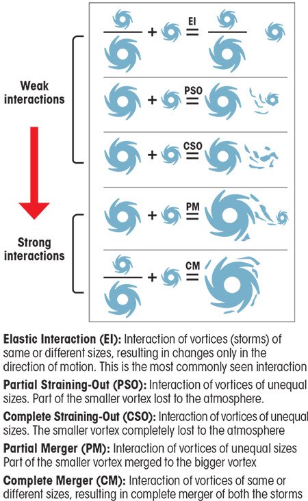
Different ways in which Fujiwhara Effect can take place:-
- The most frequent scenario is elastic interaction (EI), in which only the storms’ motion direction changes.
- These are also the cases that call for more in-depth investigation and are challenging to evaluate.
- Partial straining out (PSO), the second method, involves losing a portion of the smaller storm to the environment.
- The smaller storm is totally lost to the atmosphere in the third scenario, known as complete straining out (CSO), which does not occur for storms of comparable strength.
- The fifth type is complete merger (CM), which occurs when two storms of similar strength merge completely. The fourth type is partial merger (PM), in which the smaller storm merges into the bigger one.
- During a merger interaction between two tropical cyclones the wind circulations come together and form a sort of whirlpool of winds in the atmosphere.