
- As significant sections of North India, including Bihar, Uttar Pradesh, Uttarakhand, Haryana, Delhi, and Punjab, experience severe fog, the India Meteorological Department (IMD) has issued alerts and advisories to keep inhabitants aware of the current circumstances.
- This essay aims to clarify the science underlying these alerts and the function of the INSAT 3D satellite in delivering critical data for fog monitoring.
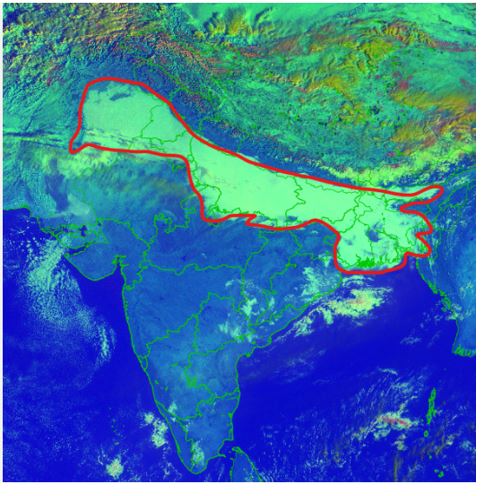
Fog Situation in North India
- Persistent fog: Since December 2023, various portions of North India have been blanketed in dense fog.
- IMD Warnings: On January 16, the IMD issued “very dense fog” warnings in numerous states, including Haryana, Chandigarh, Delhi, Uttar Pradesh, Punjab, and Madhya Pradesh, with visibility predicted to fall below 50 metres at night and in the morning.
Decoding satellite images.
- Perspectives from INSAT 3D: The INSAT 3D satellite monitors foggy conditions using photographs.
- Solar Reflectance and Brightness Temperature: These photos’ colours are influenced by two factors: solar reflectance and brightness temperature.
- Solar Reflectance: The ratio of solar energy reflected by a surface to the amount of energy received.
- Brightness Temperature: Relates an object’s temperature to the brightness of its surface as measured at various wavelengths.
Day’s Microphysics Data
- Solar Reflectance at Three Wavelengths: INSAT 3D’s ‘day microphysics’ component examines solar reflectance across three wavelengths: 0.5 µm (visible radiation), 1.6 µm (shortwave infrared radiation), and 10.8 µm (thermal infrared radiation).
- Colour Determination: The intensity of signals at these wavelengths determines the RGB (red-green-blue) colours in the picture.
- These photos are useful for analysing cloud kinds, thunderstorm phases, snow identification, and fire detection.
Night Microphysics Data
- INSAT 3D’s ‘night microphysics’ component determines two colours based on the difference between two thermal infrared signals.
- Colour Variables: The red colour corresponds to the difference between 12 µm and 10 µm signals, green to 10.8 µm and 3.9 µm signals, and blue to the intensity of the 10.8 µm signal.
- Identifying features: Night microphysics data helps to determine cloud kinds and their temperature differences.
Combining Day and Night Data.
- Comprehensive Insights: Meteorologists use day and night microphysics data to examine moisture droplets, temperature fluctuations, and the development, evolution, and depletion of meteorological phenomena like hurricanes.
- Advanced Warning Systems: Proposed uses include forecasting thunderstorms one to three hours in advance.
Radiometers & Sounders
- INSAT 3D and 3DR employ radiometers to monitor spectral properties and atmospheric sounders to analyse temperature, humidity, and water vapour levels.
- Improved Technology: Compared to their predecessors, these satellites have significantly higher spatial resolution and spectrum channels, improving India’s weather monitoring capabilities.
Future with INSAT 3DS
- Continued Advancements: The Indian Space Research Organisation intends to launch the INSAT 3DS meteorological satellite in February 2024.
- Enhanced Capabilities: This satellite will build on the achievements of its predecessors, improving India’s weather monitoring and warning capabilities.
Source: https://www.thehindu.com/sci-tech/science/insat-3d-night-microphysics-fog-map-north-india-explained/article67747369.ece